ated along the grounding line of the tidewater
Bootlegger Cove Formation
margin, would mix with outwash sand and gravel.
This is a deposit mostly of silt-size material
that covers at least 100 km2 in the Anchorage
Diamicton beds decrease in abundance up-
section, as the ice margin receded northwards.
Lowland, where it is an important confining layer
Higher in the stratigraphic sequence, gravels
in the regional ground water flow system (Ceder-
would grade to sand and silt. We question wheth-
strom et al. 1964, Freethy 1976). The unit is usu-
er or not the cantonment area was deglaciated
ally 30 to 45 m thick, although locally it may
during this time, for the Fort Richardson ice may
exceed 90 m (Cederstrom et al. 1964). The Boot-
have halted its retreat at the mouth of Knik Arm.
legger Cove Formation exists below Elmendorf
If there was a limited retreat up Knik Arm, then
Air Force Base (USAF 1994) and is exposed
the deposition accompanying it was probably
beneath the Elmendorf Moraine in coastal bluffs
short lived and the deposits thin. The uppermost
of Knik Arm (Miller and Dobrovolny 1959, Ced-
materials of the Fort Richardson sequence proba-
erstrom et al. 1964). Boreholes drilled for ground
bly consist of coarsening upward sand and gravel
water investigations near the Fort Richardson
as the ice readvanced into the area, this being the
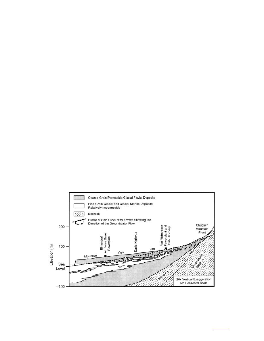
powerplant revealed a fine-grained silty horizon
Dishno Pond glaciation.
that pinched out laterally (Fig. 12) (Freethy 1976,
Anderson 1977); however, the northern and east-
Dishno Pond sequence
ern limits of this particular horizon are not
The Dishno Pond advance produced a broad
known. If the northeastern margin of the Bootleg-
diamicton (till) sheet that covers much of the
ger Cove Formation extends under the canton-
Anchorage Lowland (Plate 1). This diamicton
ment area, it is likely to be sandy and to thin from
unit unconformably overlies the coarsening
less than 10 m thick in the southsouthwest to
upward gravel deposited in front of the Dishno
nonexistent in the north and east. Such a transi-
Pond advancing ice. The diamicton should be
tional sandy phase is likely to be more permeable
similar to the Fort Richardson diamicton and be a
and hydraulically conductive than the lower por-
few to tens of meters thick. The upper contact will
tions of the Bootlegger Cove Formation common
be interbedded and gradational into gravel
to the southwest.
deposited during glacial retreat. This gravel
Well log and ground water records on Fort
Richardson attest to the presence of a confining
grades upward in section into a sandy silt and the
layer that is sometimes assumed to be the Boot-
silt of the Bootlegger Cove Formation.
a. Longitudinal profile showing the northward pinching of the Bootlegger Cove Formation.
(After Freethy 1976.)
Figure 12. Cross sections along Ship Creek.
17
to contents


 Previous Page
