Palmer area around 9000 14C
a. Advance Phase
years BP, about the same time as
Early Advance
when ice retreated to the Turn-
behind Moraine Shoal
again Pass area at the head of
Stable
Line
Turnagain Arm. It is not known
Advanced
Altitude
Position
whether or not marine submer-
gence accompanied retreat up
Knik Arm. Silt and clay deposits
found on the surface north of the
Elmendorf Moraine may point to
a short phase of submergence
beneath the sea or deposition in
Beginning
Moraine Shoal
small lakes that could have devel-
of Advance
(Morainal Bank)
oped in the hummocky glacial
deposits. Numerous stream chan-
nels were incised into the Elmen-
b. Retreat Phase
Initiation of
dorf Moraine, as well as at multi-
Early Retreat
Stable
because of
ple locations farther north. These
Advanced
Climatic Thinning
now-abandoned channels were
Position
or Changes in
Line
active near the ice margin during
Grounding-Line
Rapid Retreat
Altitude
Water Depth
by Rapid Calving
its retreat. Most of the landforms
(hummocks, drumlins, flutes,
ground moraine, etc.) north of
the Mountain View fan were
deposited during the advance
and retreat of the Elmendorf ice.
Stabilization at
Retreat Position
Moraine Shoal
(Shallow Water Depth)
CONCEPTUAL STRATIGRAPHIC
(Morainal Bank)
MODEL
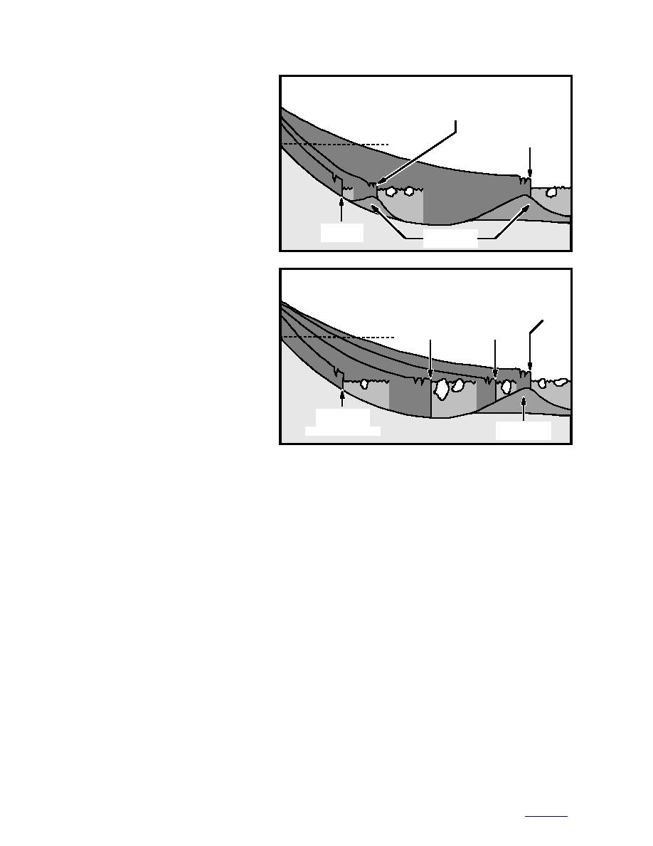
Figure 8. How a tidewater glacier can advance (a) into the marine
Surficial deposits near the canton-
environment as long as a moraine shoal protects it from deep water.
ment area are 70 to 98 m thick (Ceder-
Retreat (b) begins when deep water conditions are reestablished and it
strom et al. 1964) and are from the lat-
continues until shallow water is reached. (After Mayo 1988.)
est Wisconsinan glaciation. In the
Anchorage Lowland, southwest of the
cantonment, deposits reach more than 305 m
are also 2281 records in the USARAK's GIS of soil
thick. Diamictons from the maximum extent of
borings and well logs on Fort Richardson, but only
ice in the past (more than 120 ka BP) probably lie
146 reached depths greater than 15 m (Fig. 9). The
below the Bootlegger Cove Formation, Dishno
records from these logs contain general informa-
Pond moraine, and Mountain View fan deposits,
tion on engineering properties and material types
(e.g., USACE 1996b), but infrequent sampling
but their extent and locations are not known.
intervals (2 to 3 m) provide insufficient informa-
Diamictons from these events probably have a
tion for detailed stratigraphic analyses (all logs
low permeability and therefore are confining lay-
described in this report are included in Hunter et
ers that affect ground water conditions beneath
al. 1997). This is compounded by a lack of consis-
the cantonment.
tency in the borehole log descriptions among con-
Detailed subsurface geological information is
tractors. To achieve a better understanding of the
generally absent, except in a few locations (i.e.,
stratigraphy, we must infer subsurface characteris-
Turnagain Heights and Lynn Ary Park), where
tics from coastal exposures along the Knik Arm
geotechnical studies have been carried out to
and Eagle River, extrapolation from nearby deep
determine the cause of ground failure during the
wells, limited interpretation of ground-penetrat-
1964 earthquake (e.g., S&W 1964, Lade et al. 1988,
ing radar (GPR) profiles, and a reconstruction of
Updike et al. 1988) or to investigate ground water
the glacial history.
conditions (e.g., Freethy 1976, Anderson 1977,
A conceptual stratigraphic model for the can-
Dearborn 1977, Munter and Allely 1992). There
13
to contents


 Previous Page
