high hydrostatic head to lower hydrostatic head)
develop from the normal flow of water in these
in either an unconfined or confined aquifer. The
channels and are interbedded with the debris-
confined aquifer often has artesian water; the
flow diamictons (Jopling and MacDonald 1975).
potentiometric surface is of higher elevation than
Overall, the alternation between debris flow
the base of the confining layer. Regionally,
deposition and stream channel migration pro-
ground water in the Anchorage Lowland flows
duces a complex interbedded sequence of gravels
roughly from the Chugach Mountains to Knik or
and diamictons that probably characterizes the
Turnagain Arms. It discharges where streambeds
north cantonment area.
intersect the water table (i.e., lower reach of Ship
Creek), where the ground water table intersects
HYDROGEOLOGY
the surface, forming ponds and lakes, or where
the confining layer is truncated (i.e., coastal
Regional
bluffs), producing seeps and springs.
The hydrogeology of the Anchorage Lowland
The hydrogeology in the Anchorage area has
has been extensively studied, as researchers have
traditionally been treated as a three-component
examined various ground water issues (e.g.,
system, consisting of an upper unconfined and a
Cederstrom et al. 1964, Waller 1964, Barnwell et
lower confined aquifer, separated by a confining
al. 1972, Freethy 1976, Anderson 1977, Zenone
horizon with low permeability (Cederstrom et al.
and Anderson 1978, Dearborn and Schaefer 1981,
1964, Freethy 1976, Anderson 1977). The silty clay
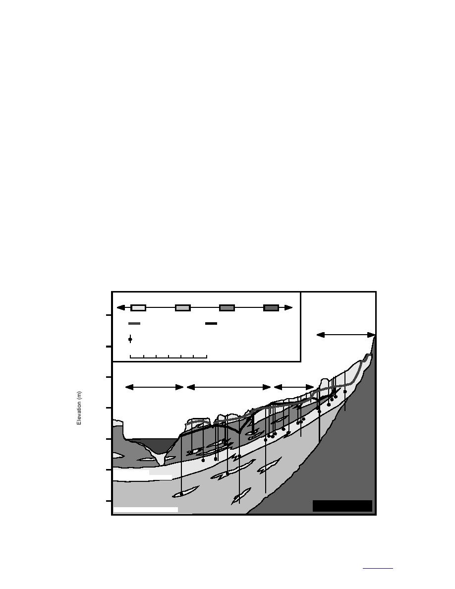
Munter and Allely 1992). The overall setting is
to clayey silt of the Bootlegger Cove Formation is
reasonably well known (Fig. 14). Water enters the
generally thought to be a confining layer because
ground water system through runoff along the
of its low hydraulic conductivity (e.g., USAF
mountain front, percolation of rain and snowmelt
1994). The Bootlegger Cove Formation extends
across the region, stream infiltration in losing
across most of the Anchorage Lowland (Ulrey
river reaches, and seeps from bedrock fractures
and Updike 1983), but probably pinches out
(Table 2). The water flows down-gradient (from
Permeability
Very High
Very Low
200
Water Table
Potentiometric Surface
(Unconfined Aquifer)
(Confined Aquifer)
Fort Richardson
Borehole or Well Where Water Level Was Monitored
150
0
2000
4000
6000 m
Muldoon
100
Area
Knik Arm
City of Anchorage
50
Knik Arm
Sea
Level
Silty Clay
and Clay
50
Sand and Gravel
(Principal Confined Aquifer)
100
Consolidated Sediments
and Metamorphic Bedrock
Poorly Sorted Glacial Sediment
Figure 14. Generalized hydrogeologic cross section from the Chugach Mountains to Knik Arm. (After
Barnwell et al. 1972.)
20
to contents


 Previous Page
