ice retreat and subsequent read-
vance produce a proglacial strati-
graphic sequence consisting of a
Correlative Map Units
Hydrologic Units
gravel that fines upward (decreas-
Retreat
Advance
Correlative Map Units
Hydrologic Units
Retreat
Advance
ing millimeter grain size) to thinly
laminated silt, followed by a sand
Mountain View Fan
Mountain View Fan
that grades upward to a gravel (Fig.
11). The upward fining in the lower
portion of the sequence records an in-
crease in distance from the margin as
Elmendorf Moraine
Elmendorf Moraine
it retreats. This results in an increase
in the percentage of sediment
deposited from suspension in the
sea water (e.g., Dowdeswell and
Murray 1990, Cowan and Powell
Confining Layer
Bootlegger Cove Formation
1990). These silt layers, therefore,
ConAnichoLage r
fin ng r aye
Bootlegger Cove Formation
in
in Anchorage
are the product of deposition when
ice was located closer to the head of
Knik Arm. Silt grading upwards to
gravel in the upper portion of the
Dishno Pond Moraines
Inhomogeneous
Dishno Pond Moraines
IChomongneous
n onfinige Layer
sequence records the advance of ice
Conf(iLeaky) yer
ning La
into a marine basin behind a
(Leaky)
morainal shoal (Post 1975, Mayo
Marine Inundation
Marine Inundation
1988). Suspension settling was grad-
ually replaced by sand and gravel
Fort Richardson Moraines
Inhomogeneous
Fort Richardson Moraines
IChomongneous
n onfinige Layer
deposition from sediment gravity
Conf(iLeaky) yer
ning La
(Leaky)
flows (turbidites and debris flows)
Marine Inundation (?)
Marine Inundation (?)
generated by failures of the sub-
Rabbit Creek Moraines
marine moraine as the ice advances.
Rabbit Creek Moraines
A diamicton (or till) was deposited
Bedrock/
Bedrre-ck/isconsinan Diamicton
P oW
by the glacier as it overrode the pro-
Pre-Wisconsinan Diamicton
glacial deposits (e.g., Hunter et al.
Time Stratigraphic Units
Time Stratigraphic Units
1996b). The thickness of the strata, as
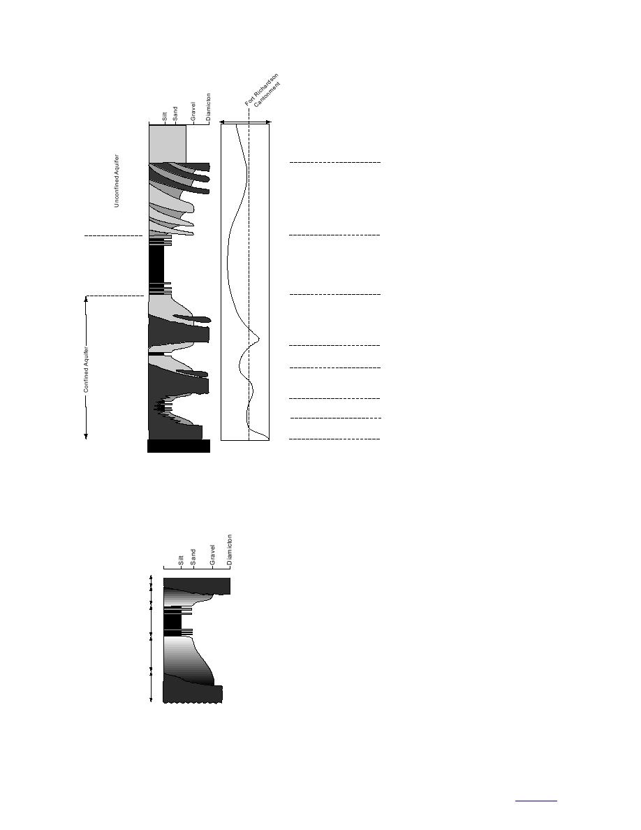
Figure 10. Conceptual timestratigraphic model for Fort Richardson
well as the sedimentary sequence,
below the cantonment area.
depend on the rate, extent, and dura-
tion of retreat and readvance, the
local importance of other sediment sources, and
the length of time that the deposits are exposed to
subglacial and subaerial processes after they were
deposited.
Stillstand Phase
To develop a model of the sedimentary stratig-
Advance Diamicton
raphy for Fort Richardson, it is thus critical to
Advance Phase
Glacial-Marine Stratified
Sand and Gravel
know the extent of the retreat, as well as the ad-
vance, of the Fort Richardson, Dishno Pond, and
Interglacial Phase
Estuarine Silt
Elmendorf glaciations. Unfortunately, this is not
well known. Schmoll et al. (1996) note that estua-
Retreat Phase
Glacial-Marine Stratified
rine silt was deposited in the North Fork Campbell
Sand and Gravel
Creek and Chester Creek areas following both the
Fort Richardson and Dishno Pond retreats. Its
Stillstand Phase
Basal Diamicton
presence implies intertidal conditions and marine
submergence, but the extent of this submergence
Figure 11. Conceptual stratigraphic sequence.
up Knik Arm is not known. We assume that the
cantonment area was also deglaciated, but proba-
bly for a relatively short time.
15
to contents


 Previous Page
