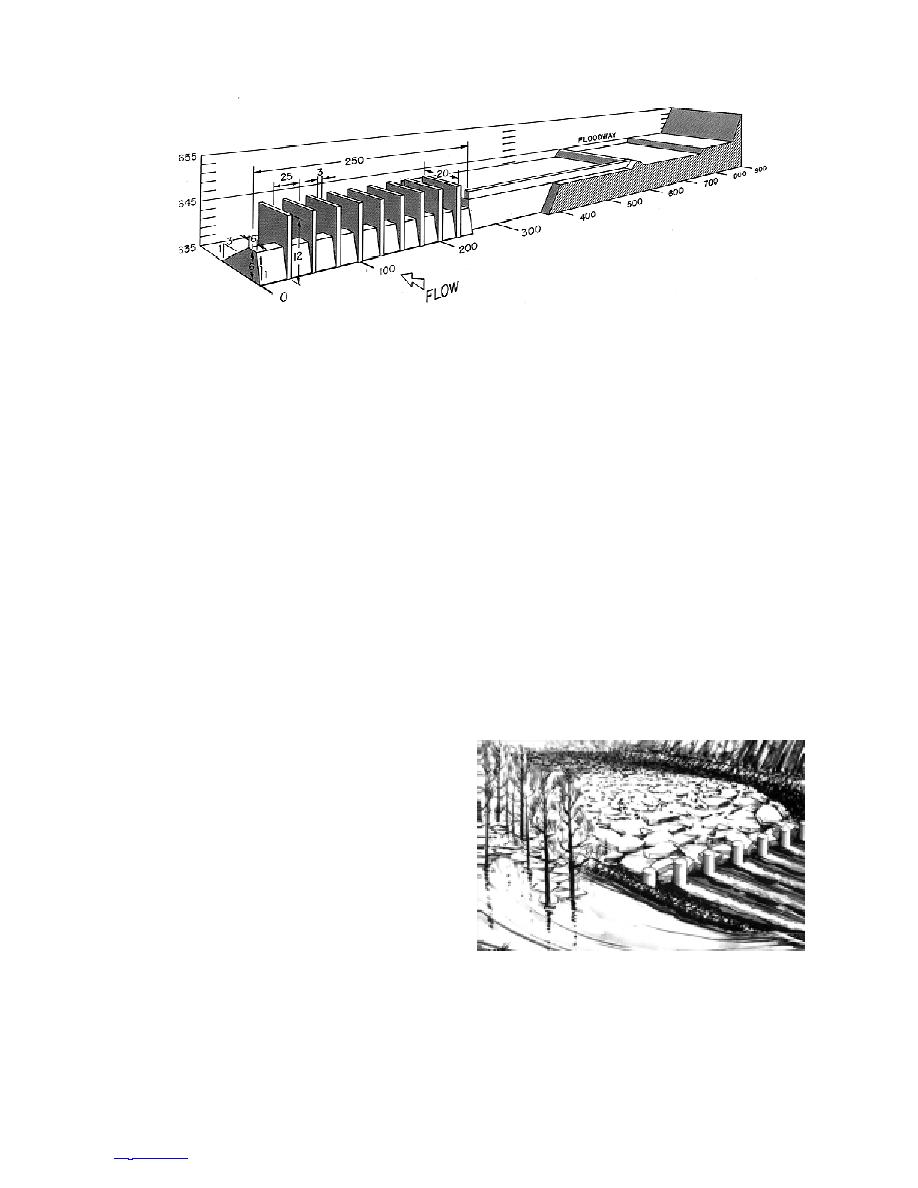
Figure 2. Concept drawing of original Cazenovia Creek ICS. Dimensions and elevations shown
are prototype feet. Not shown is a low-flow gated opening in the weir to allow fish passage from spring to
early winter. In its final design, the ICS piers were 12 ft long. A pool for storage of ice floes was to be
excavated pool at elevation 635; it was 400 ft wide at the ICS and tapered linearly to the natural channel
width (approximately 160 ft) at a distance of 600 ft upstream. The project also required extensive grading
and riprap protection for the floodway bypass channel.
both West Seneca and Buffalo, are heavily developed.
weir with nine ice-retaining piers, an excavated pool to
Consequently, we sought greater ice-retaining capac-
store ice pieces, and a prepared floodway to bypass the
ity for the Cazenovia ICS.
peak flow (Fig. 2). The project was estimated to cost
Figure 3 shows the new ICS concept proposed for
,100,000 (1987 dollars), reduce average annual ice-
Cazenovia Creek. It consists of evenly spaced cylin-
jam flood damages by 0,000 (1987 dollars), and
drical piers anchored in main channel and does not
achieve a benefit/cost ratio of about 1.5 over the life of
include a weir. The adjacent treed floodplain is left intact
the structure. Nevertheless, it was not built. Federal law
to act as a flow-bypass channel. In proposing this ICS,
was changed at that time to require 25% cost sharing
we expected that vertical piers spaced the same dis-
by the local sponsor. The Town of West Seneca could
tance apart as the Hardwick ICS blocks would offer
not afford this amount on its own, and New York State
significantly better ice-retention capability, especially
had not yet modified its laws to participate as a spon-
for thinner ice. Nevertheless, we needed to quantify this
sor.
and verify that piers alone would offer the same or bet-
Many communities along small northern rivers
ter performance as the original weir-with-piers ICS.
experience severe ice-jam flooding. Although flood dam-
Also, we needed to determine design ice loads on the
ages can be significant, ICS's that include weirs, dams,
piers. We therefore conducted physical model tests of
or levees are often too expensive to achieve benefit/cost
the new ICS.
ratios over unity. In 1991, CRREL began research spe-
cifically to reduce ICS costs for small rivers. The result
for breakup ice jams was the sloped-block ICS, devel-
oped using model tests, and demonstrated in the Lam-
oille River in Hardwick, Vermont (Lever et al. 1997,
Lever and Gooch 1998). The Hardwick ICS consists of
four massive, sloped blocks placed across the river ad-
jacent to a treed floodplain. The blocks arrest a break-
up ice run and form a stable, partially grounded ice jam.
Trees on the floodplain retain ice pieces in the river
channel while allowing flow to bypass the structure.
The large gaps between blocks (14 ft) allow easy fish
and canoe passage.
The sloped-block ICS has performed well, and no
ice-jam flooding has occurred in Hardwick since its
Figure 3. Concept drawing of new Cazenovia Creek
ICS. Cylindrical piers of 5 ft diameter 10 ft tall with 10- to
construction in 1994. However, for ice less than 1 ft
thick, the ICS released the ice jams after several hours.
14-ft gaps anchored in main channel (no weir) arrest a
breakup ice run and retain the ice jam throughout an event.
This does not pose a problem in Hardwick and is a con-
Treed floodplain bypasses flood flow but not ice floes.
sequence of the safety-valve feature of the sloped blocks
Raised riprap embankment near ICS prevents scour and
to minimize peak loads (and construction costs). But
ensures floodplain flow returns to main channel down-
many areas downstream of the Cazenovia ICS site, in
stream of ICS. The riverbed at the ICS site is bedrock.
2
TO CONTENTS


 Previous Page
