4000
3000
Power
Canal
2000
1000
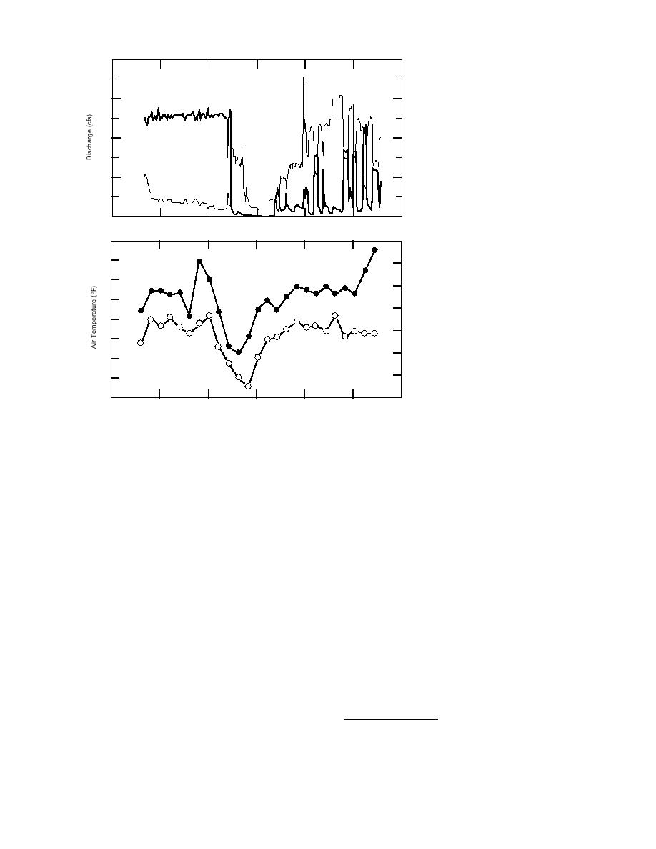
a. Flows measured at USGS gages
Loup
River
on the Loup River near Genoa and
the Loup River Power Canal near
0
Genoa.
12 Nov `93
17
22
27
2 Dec
7
12
70
60
Maximum
50
Air Temperature
40
30
20
Minimum
10
b. Minimum and maximum daily
0
air temperatures measured at
10
Columbus.
12 Nov `93
17
22
27
2 Dec
7
12
Figure 4. Loup River flows and daily air temperatures, 15 November through 9 December 1993.
Nebraska Civil Defense records indicate that ice-
about 0.8 mile downstream from the Highway 30-
jam-related flooding also occurred at the Monroe
81 bridge is reflected in the records of the USGS
Bridge in January 1980. This ice jam resulted in
gaging station that was operated at the bridge
lowland flooding for several days before break-
from 1935 through 1978. Gage records revealed
ing up.
that peak stages due to backwater from ice (i.e.
According to local residents, severe ice jams
the ice jam was downstream from the gage but
also occur downstream at Oconee Bend, east of
raised water levels at the gage) occurred in 1936,
Monroe and about a mile west of Oconee (Fig. 3).
1958, 1961, 1963, 19691971 and 19731977 (Table
The ice jam at this location is said to be a recur-
5). The records also showed that the ice jam itself
ring one, with the toe at the downstream end of
extended beyond the gage in 1978.
the bend. On 14 March 1978, Nebraska Civil De-
Local residents provided information on an
fense records indicated that ice-related overbank
additional jam that occurred in February 1948,
flooding was taking place at this location.
causing ,000 in damages. This jam caused high
Some residents reported an ice jam at Oconee
stages during the week of 1421 February 1948,
Bend in March 1993. The Columbus Daily Telegram
but the maximum stage (not reported) did not
reported overbank flooding at Oconee Bend on
occur until 28 February 1948. An additional ice
Monday, 9 March 1993, but ice was not specifical-
jam was reported in Nebraska Civil Defense
ly mentioned. No other specific data on jam dates,
records* on 15 February 1966. This ice jam, locat-
length of jam, stages or damages due to ice jams
ed in the Wagner LakeSand Pit area west of Co-
at Oconee Bend were given.
The most damaging ice jams on the lower por-
tion of the Loup River have occurred at Colum-
* Memorandum of aerial reconnaissance, William J.
bus. The presence of a recurring ice jam that forms
Clark, 16 February 1966.
8


 Previous Page
