Table 9. Approximate length, minimum width, and depth of key straits (from DMA 1993;
RSMOT, in prep.).
Length
Width
Depth
Strait
Location, passage fromto
(nm)
(nm)
(m)
Yugorskiy Shar
Novaya Zemlya, BarentsKara Seas
21
6
12
Karskiye Vorota
Novaya Zemlya, BarentsKara Seas
18
14
21
Matochkin Shar
Novaya Zemlya, BarentsKara Seas
55
1
12
Vil'kitskogo
Severnaya Zemlya, KaraLaptev Seas
60
30
25
Shokal'skogo
Severnaya Zemlya, KaraLaptev Seas
80
10
37
Dmitriya Lapteva
Novosibirskiy, LaptevEast Siberian Seas
63
30
6.7
Sannikova
Novosibirskiy, LaptevEast Siberian Seas
120
16
13
Longa
Wrangel Island, East SiberianChukchi Seas
--
75
20
Yugorskiy Shar Strait, between the Barents and
north of Wrangel Island. The average straight-line
Kara Seas, is approximately 21 nm in length, about
distance from the straits of the Novosibirskiy Is-
5.5 nm wide at its narrowest point, and trends in
lands to the Bering Strait is 1090 nm, and the total
a southwest-to-northeasterly direction. Depths in
distance from Murmansk is 27203520 nm.
this strait are very irregular, with several off-lying
Table 9 summarizes the approximate lengths,
shoals and shallow banks that extend far offshore.
widths, and depths for the straits described above.
The marked fairway has a minimum depth of 12
Other distances of interest may be obtained from
m, but the water level is increased somewhat by
Table 10.
east winds and lowered by west winds. Tidal
variations in depth are normally 0.9 m. Surface
The major straits used for passage
currents usually flow from the Barents to the Kara
The sources for the following information are
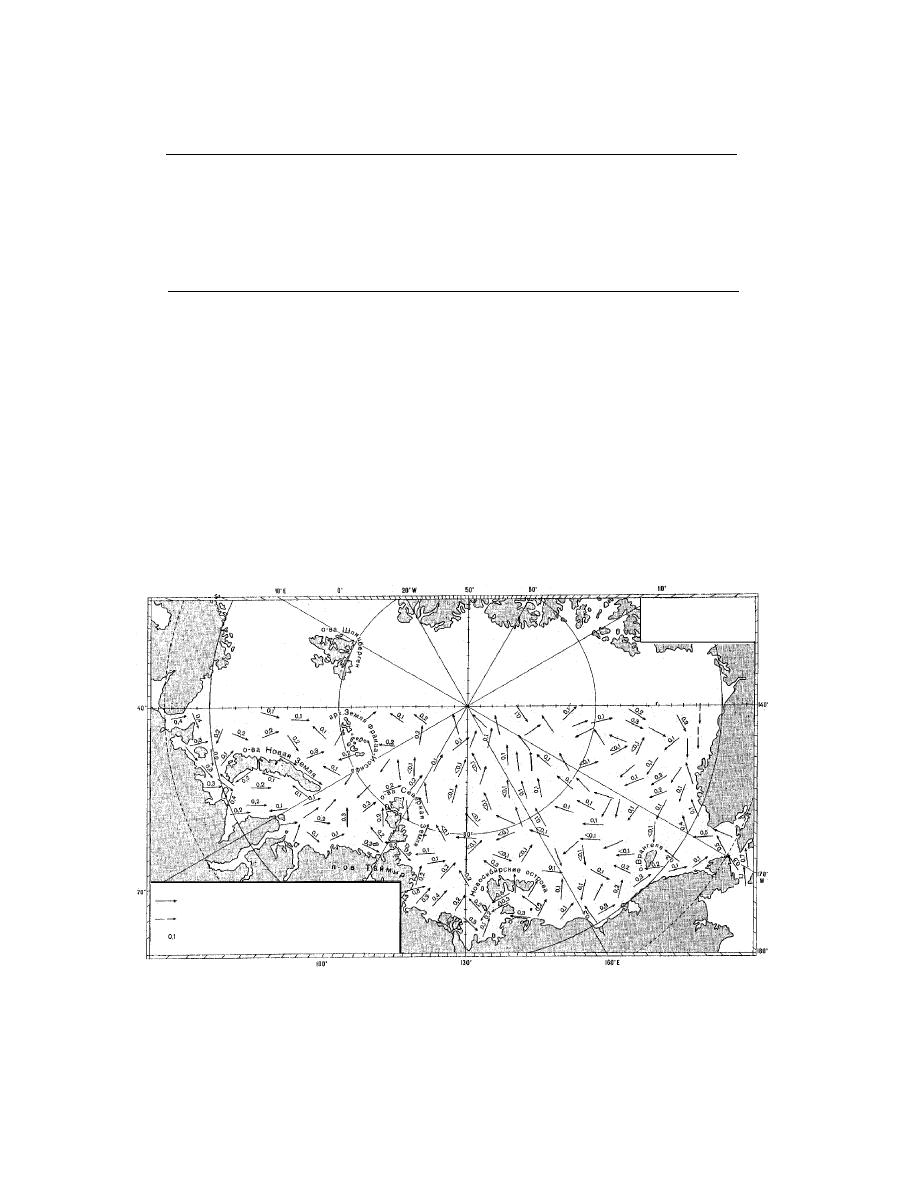
at a rate of 0.250.5 kn. Figure 21 shows the gen-
DMA (1993), Kjerstad (1994), and RSMOT (in
eral scheme of surface currents during the period
prep.) unless otherwise indicated. The major navi-
of navigation for the entire Russian Arctic. Maxi-
gable straits are shown on Figure 1.
Navigation Period
(July October)
Direction of Current
Assumed Direction of Current
Velocity (knots)
Figure 21. General scheme of constant surface currents (010 m deep) during the normal period of
navigation (July through October). Constant currents are sometimes called "permanent currents" and
are distinct from those due to wind and tides. They result primarily from the presence of water density
gradients and can change with the seasons. (Translated from RSMOT, in prep.)
32


 Previous Page
