(American Geological Institute 1989). Thickness
(1964, 1965), Reger and Updike (1983, 1989), and
estimates are based on unevenly distributed field
Schmoll et al. (in press). Bedrock crops out mainly
observations and limited subsurface data; for
in the Chugach Mountains, and was not examined
many deposits, especially in the mountains, data
in detail in any of the maps and reports cited
are lacking and thickness estimates are based in
above, but is mapped in parts of the area at
large part on geomorphic considerations.
1:63,360 scale by Clark and Bartsch (1971). Bed-
Especially near mapped bedrock or on moun-
rock of the entire area is included in the 1:250,000-
tain slopes mapped as colluvium, bedrock may be
scale reconnaissance map of Clark (1972) that
present at relatively shallow depth. Elsewhere,
served as the basis for subsequent regional compi-
however, bedrock lies at considerable depth. In the
lations at the same scale by Magoon et al. (1976)
descriptions that follow, "bedrock" refers to the
and Winkler (1992).
metamorphic rocks of map unit bo. The term "older
The Fort Richardson map area lies athwart the
bedrock" is used only selectively to avoid ambigu-
boundary between two physiographic provinces,
ity with the term "younger bedrock," which is
the Anchorage Lowland and the Chugach Moun-
used for the Tertiary continental rocks of map unit
tains. This boundary extends diagonally across the
by.
map area from northeast to southwest and is
marked by an abrupt rise of the mountains known
The units described here may be overlain by as
much as 1 m of organic and windblown (including
as the Chugach Mountain Front. In the southern
volcanic) materials that thicken locally and grade
part of the map area, the margin of the lowland
into map unit p. In the urbanized parts of the map
northwest of the front consists of a higher-lying,
area, much of this mantle has been removed or
southwest-widening belt of foothills known as the
Hillside area.
otherwise modified. Where the mapped deposit
has also been significantly altered, in some places
The characteristics of the surficial geologic
the landform destroyed, a suffix u is added to the
materials delineated by the map units described
map-unit designator. Slope information is derived
here are based primarily on field observations;
from or based on geomorphic analogy to estimates
they are supported in part by laboratory analyses,
presented in Schmoll and Dobrovolny (1972b),
especially of grain size, the descriptions of which
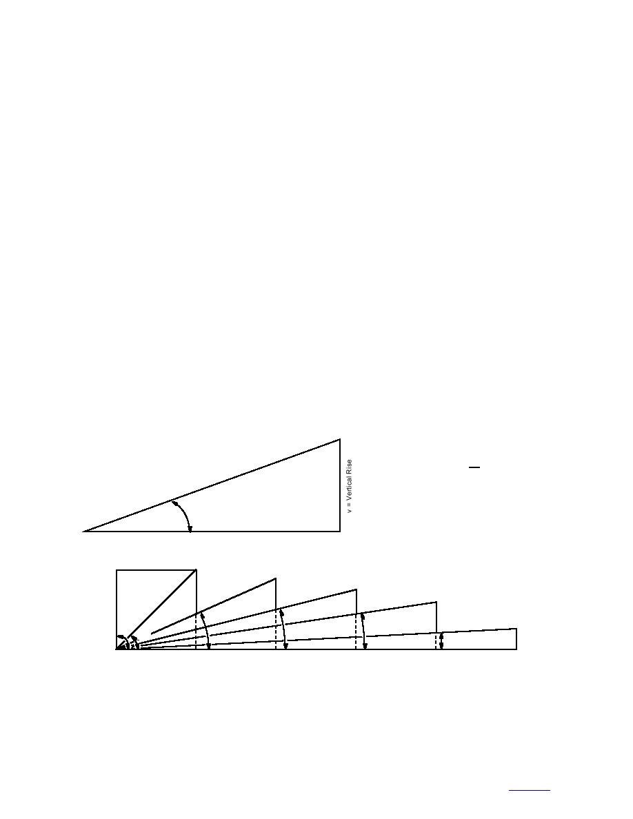
whose slope categories are used (Fig. A2). Stan-
follows the modified Wentworth grade scale
ce
urfa
S
und
= v 100
Gro
Slope in Percent
h
Slope Angle in Degrees = a
Slope Ratio
= h:v (h to v)
where v is equal to
a
1 unit of measurement
h = Horizontal Distance
1
1
1
1
14
24
8.5
1
90
45
3
1
2.2
4
6.7
20
90
Slope: Precipitous Slopes (∞%)
45
Slope: Very Steep Slopes (100%)
24
Slope: Steep Slopes (45%)
14
Slope: Moderate Slopes (25%)
8.5 Slope: Gentle to Moderately Gentle Slopes (15%)
Figure A2. Slope categories used in these descriptions. (After Schmoll and Dobrovolny 1972b.)
42
to contents


 Previous Page
