A
A'
East
Distance (m)
West
0
50
100
150
200
250
300
350
Truck Fill Stand
Canol
Slough
Road
BH
BH
BH
BH
0
?
10
?
?
20
?
30
?
?
40
50
Permafrost
Unconsolidated Alluvium
Weathered Schist Bedrock
Schist Bedrock
(silt, sand and gravel)
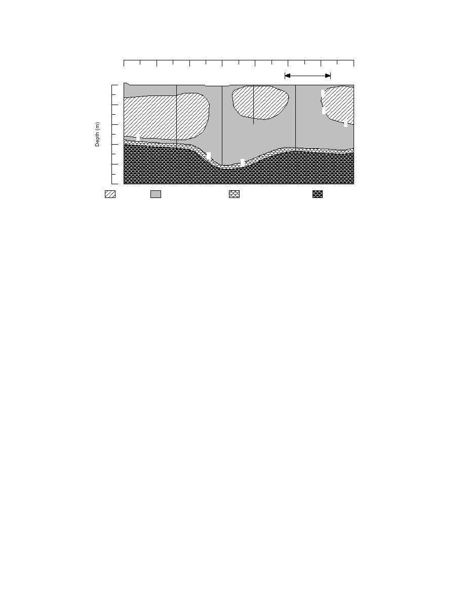
Figure 11. Cross section A-A' (survey line 62 (94), Fig. 6) illustrating the relationship
between areas of permafrost that extend into bedrock and the rapid transition from
unfrozen to frozen materials.
Birch Hill with the subpermafrost aquifer south of
site (Fig. 10a and b) limits the potential interac-
the site.
tion of both supra- and subpermafrost aquifers in
In addition, the trend and location of the bur-
the study area with the aquifer further to the east.
ied valley align reasonably well with a gully
It will thereby also affect the hydraulic gradient
present on the hillside within the Tank Farm (Fig.
within the site and may result in directions of
flow that respond to more local ground water
10b). We speculate that this ravine and the buried
sources. Birch Hill may influence ground water
valley are related, and that both follow a fracture
flow, given its elevation and the potential effects
zone within the bedrock. This fracture zone may
of water influx at its surface. Exposures of schist
also be sufficiently permeable to transmit ground
within quarries on the south side of Birch Hill
water within the bedrock.
reveal numerous fractures from which water com-
monly seeps. Such fractures may therefore be
Aquifers
zones of highly localized ground water flow
Unfrozen sediments of former channels in the
within Birch Hill and beneath the Chena River
Canol Road area represent aquifers through which
flood plain, creating localized piezometric gradi-
there may be significant flow of ground water
ents in the suprapermafrost and subpermafrost
(Fig. 10a). These aquifers evidently merge near
aquifers that are difficult to predict.
the Truck Fill Stand and are continuous, with
The subpermafrost aquifer, however, will also
more extensive unfrozen zones near the Steese
be in communication with ground water further
Highway. They are also probably continuous with
south in the Chena River area (Fig. 10b). This area
the subpermafrost aquifer south and west of the
is more likely to be controlled by the subregional
site (Fig. 10b). Unfrozen colluvial sediments at
flow system, which numerous studies have shown
the base of Birch Hill may also represent a signifi-
to have a general west to northwest gradient (e.g.,
cant shallow aquifer, providing a route for ground
Williams 1970, Pw et al. 1976, Ecology and Envi-
water migration parallel to the top of the slope.
ronment 1994). Therefore, both local and subre-
Deeply thawed areas beneath Canol Road and
gional ground water controls may determine flow
the Truck Fill Stand support a suprapermafrost
patterns and velocities within the subpermafrost
aquifer. Unfrozen channel deposits provide a di-
aquifer of the immediate site. Flow within the
rect connection between this suprapermafrost
unfrozen channel aquifers may be affected because
aquifer and the subpermafrost aquifer.
of their communication with the subpermafrost
The large area of permafrost frozen to bedrock
aquifer.
with a thin active layer east and southeast of the
12


 Previous Page
