EM 1110-2-2907
1 October 2003
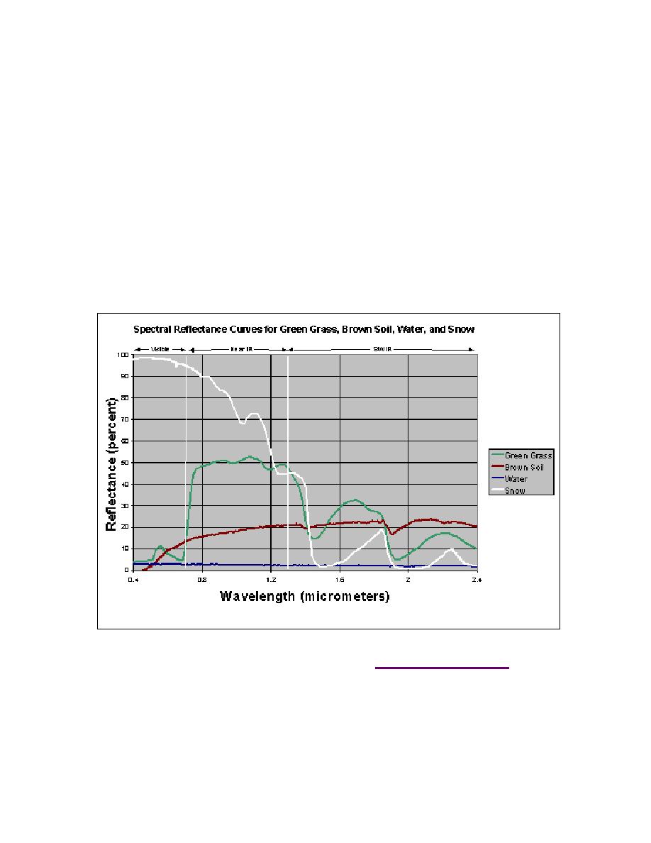
(6) Critical Spectral Regions. The spectral regions that will be most useful in a
remote sensing application depend on the spectral signatures of the surface features to be
distinguished. The figure below (Figure 2-24) shows that the visible blue region is not
very useful for separating vegetation, soil, and water surface types, since all three have
similar reflectance, but visible red wavelengths separate soil and vegetation. In the near-
IR (refers to 0.7 to 2.5 m), all three types are distinct, with vegetation high, soil inter-
mediate, and water low in reflectance. In the shortwave IR, water is distinctly low, while
vegetation and soil exchange positions across the spectral region. When spectral signa-
tures cross, the spectral regions on either side of the intersection are especially useful.
For instance, green vegetation and soil signatures cross at about 0.7 m, so the 0.6- (visi-
ble red) and 0.8-m and larger wavelengths (near IR) regions are of particular interest in
separating these types. In general, vegetation studies include near IR and visible red data,
water vs. land distinction include near IR or SW IR. Water quality studies might include
the visible portion of the spectrum to detect suspended materials.
Figure 2-24. Spectral reflectance of grass, soil, water, and snow. Graph developed for
Prospect (2002 and 2003) using Aster Spectral Library (http://speclib.jpl.nasa.gov/) data
(7) Spectral Libraries. As noted above, detailed spectral signatures of known ma-
terials are useful in determining whether and in what spectral regions surface features are
distinct. Spectral reflectance curves for many materials (especially minerals) are avail-
able in existing reference archives (spectral libraries). Data in spectral libraries are gath-
ered under controlled conditions, quality checked, and documented. Since these are re-
2-27


 Previous Page
