vated for cold weather maneuvers and named the Arc-
River usually are covered with Pleistocene loess de-
tic Training Center in 1949. Designations and purposes
posits varying from a few centimeters on hilltops to
changed throughout the 19501990's, but activities
over 14 m in low-lying areas. Some loess has been
mostly focused on cold weather training. Most of the
retransported from hills to the valley bottoms where it
facilities were constructed during the 1950's, includ-
forms deposits of laminar to massive silt rich in organic
ing the military's first nuclear power plant. Chemical
debris (Pw 1975, Pw and Reger 1983).
and biological weapons were tested during the 1950's.
Glaciofluvial sediments both from the Delta creek gla-
Under the Base Realignment and Closure Act of 1995,
ciations and modern glaciers are evident throughout the
Congress designated a portion of the Main Post to be
study area (Holmes and Benninghoff 1957, Pw et al.
closed and training activities were to be realigned with
1966, Pw 1975, Pw and Reger 1983). Moraines
Fort Wainwright. Fort Greely currently is used for ar-
from the Delta and Donnelly glaciations form promi-
tillery and mortar firing, aerial gunnery, small arms fir-
nent deposits in the valleys (Pw and Holmes 1964,
ing, platoon to brigade exercises, and bivouacs because
Pw and Reger 1983, Ten Brink 1983).
of the large area and the unique opportunities for cold
Soils of the study area tend to be poorly developed
weather testing, glacier training, mountaineering, river
Inceptisols, undeveloped Entisols, or Histosols (Rieger
rafting, and ice-bridge construction. The U.S. Air Force
et al. 1979). Ochrepts (well-drained Inceptisols that have
is a major user of Fort Greely and has designated the
only small amounts of organic matter at the surface)
Oklahoma/Delta Creek Impact Areas as the primary
occur on hills where permafrost generally is absent.
sites for military aircraft training.
Aquepts (wet Inceptisols with thin to thick layers of
The continental climate of interior Alaska has ex-
poorly decomposed organic matter) are found in poorly
treme annual temperature variations and low precipita-
drained areas and are commonly associated with ice-
tion. Light surface winds are typical over most of the
rich permafrost. Aquents or Fluvents (wet mineral
region, though mountain passes, including the Fort
Entisols associated with shallow or deep water tables)
Greely area, can experience strong, gusty winds. Ac-
occur on floodplains and seepage areas. Histol soils,
cording to U.S. Weather Bureau records (19371998),
such as Fibrists (deep organic soils made up mostly of
the mean annual temperature is 2.3C, with extremes
undecomposed sedges or mosses), are seen in depres-
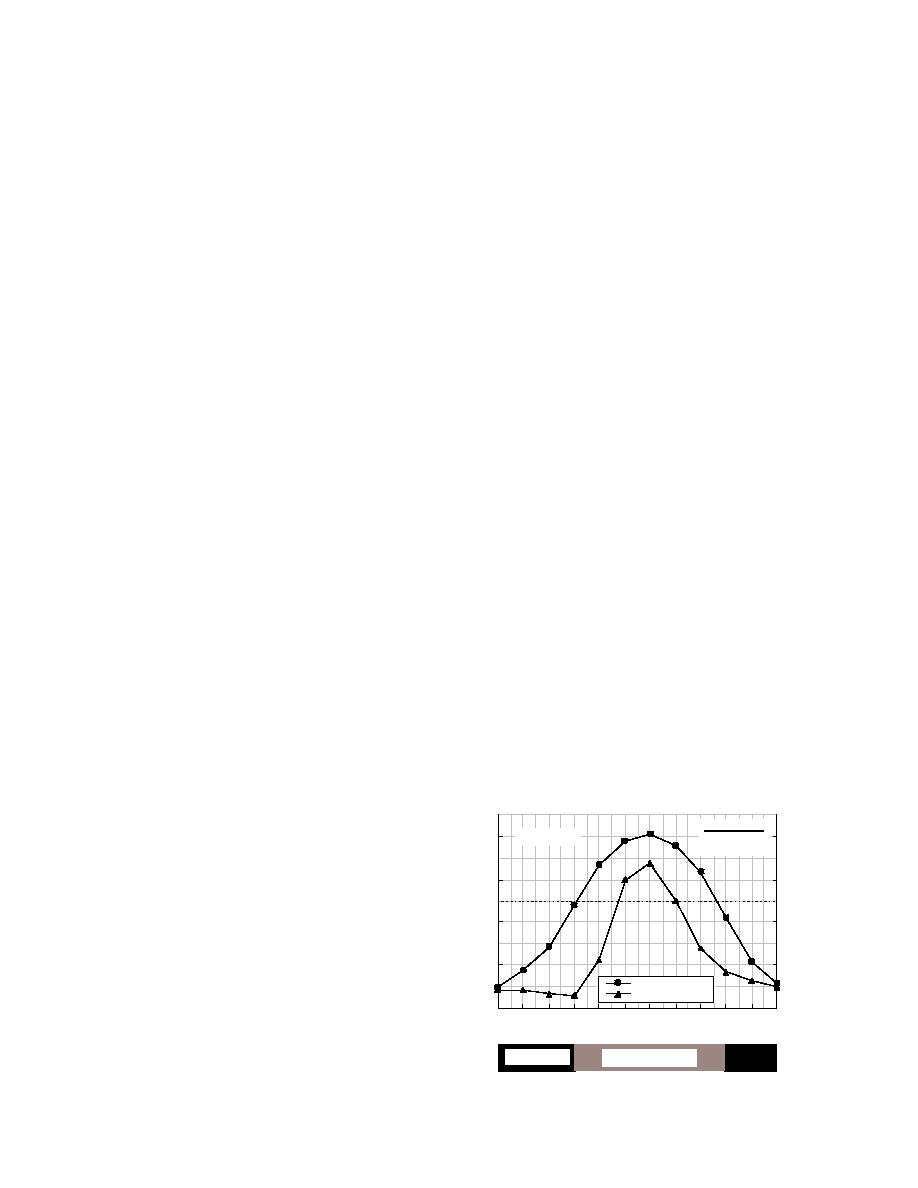
ranging from 51 to 38C (Fig. 3). The mean monthly
sions or wet areas in which the soil is saturated for long
temperature is 15.6C for July and 19.9C for Janu-
periods. Permafrost may or may not be present in these
organic soils. Overall, permafrost tends to occur on
ary. The average annual precipitation is 297 mm and
north-facing slopes and valley bottoms and is absent
annual snowfall averages 178 cm. Most precipitation
on south-facing slopes, in coarse-grained sediments, and
falls during June and July.
in areas of groundwater movement (Viereck et al. 1986,
The bedrock geology of interior Alaska is dominated
Williams 1970).
by Precambrian micaceous schist of the Birch Creek
Within interior Alaska, the interrelationships among
formation, but also includes metamorphic, sedimentary,
geomorphology, slope, aspect, hydrology, permafrost,
and volcanic rocks of Paleozoic age (Pw et al. 1966,
and fire result in a complex pattern of vegetation types
Wilson et al. 1998). Upland areas adjacent to the Delta
Big Delta (387 m)
0
mm
C
Annual Means
1937-1998
80
15
-2.3 0 C
297mm
60
5
Figure 3. Climate at the Big Delta station near
Fort Greely (mean monthly temperature and pre-
40
-5
cipitation).
20
-15
Temperature (o C)
Precipitation (mm)
0
-25
J
F
M
A
M
J
J
A
S
O
N
D
Frost Possible
Cold Season
5


 Previous Page
