Detailed studies would be required to determine whether the frequency of jamming has been altered by this ice control
structure. However, even though it is much smaller than desired, the structure has reduced the severity of ice jam floods by
capturing some frazil ice and delaying somewhat the downstream movement of ice during breakup.
In 2000, CRREL was asked by NAE Emergency Operations to provide technical support for a number of New England
communities affected by ice jams. CRREL determined that an early warning flood notification system would provide the
most economical and effective advance measure for reduction of flood damage caused by ice jam flooding in Lancaster.
Two conditions of flood stage on the Israel River were selected for monitoring: rate of rise in a 24-hour period and
overbank flood stage. Both events can signify the potential for flooding that occurs as the result of an ice jam. If the Israel
River rises 18 inches in a 24-hour period, or if the river reaches overbank conditions, the notification process is activated.
The Lancaster system also includes water temperature measurements, which can be used to signal potential frazil ice
production and the start of freezeup jamming. The system uses landline power and standard telephone because cellular phone
service in Lancaster is limited. The notification system via landline telephone notifies the 24-hour Fire Department dispatch,
the Town Hall telephone, and the home telephone of the Public Works Director using a prerecorded message.
A public Web page interface has been incorporated into the early warning flood stage system to allow emergency
response personnel in Lancaster to visually inspect the status of the Israel River from any computer that has access to the
World Wide Web. The Web page interface is updated every two hours via a computer located at CRREL that retrieves data
from the remote site and automatically updates the Web page.
3
2
1
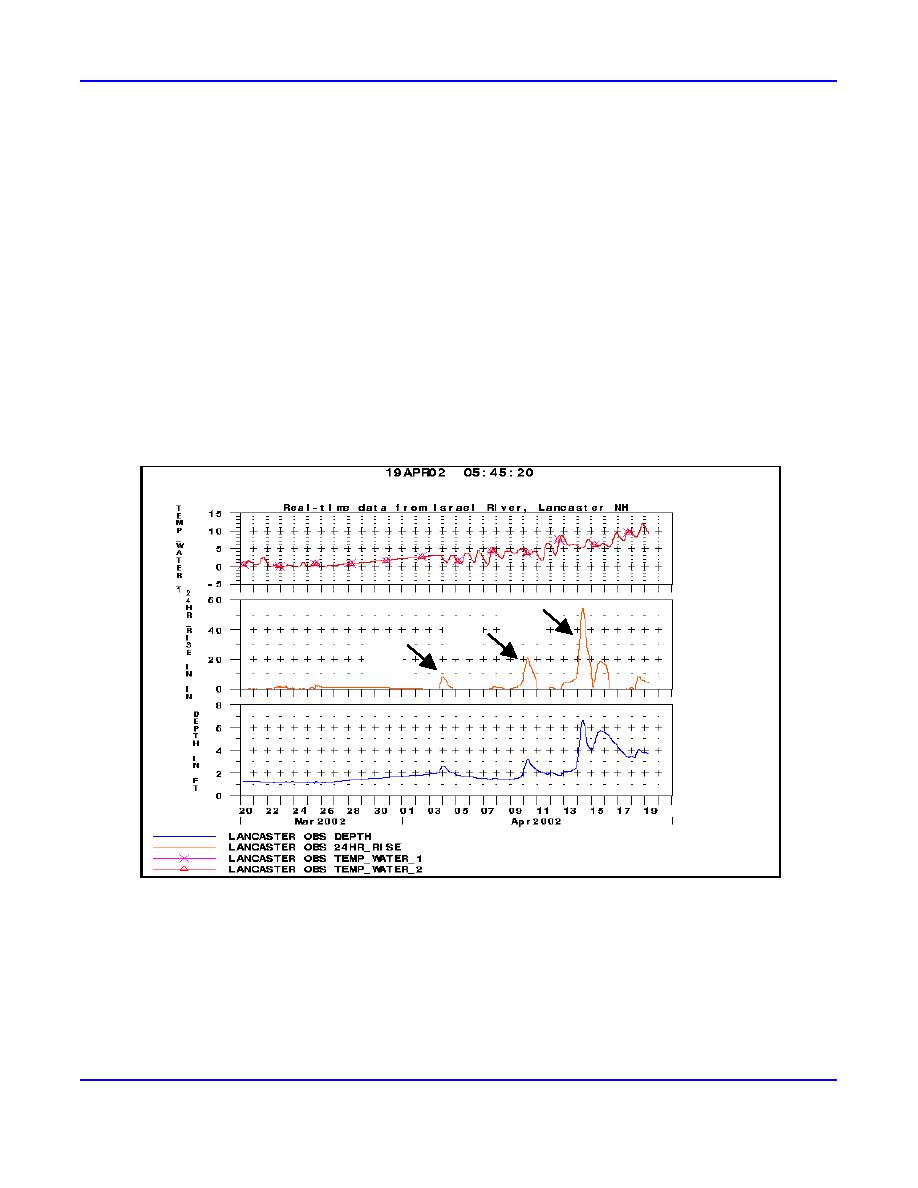
Figure 4. Lancaster Web page interface, showing three events. The first event did not exceed alarm thresh-
olds and did not result in flooding. The second and third events did trigger alarms.
Figure 4 shows a sample plot of data from the CRREL Web page. The first event, on 3 March 2002 (marked 1), was the
formation of a breakup jam just downstream of the pressure transducer that did not meet either criterion for notification. The
second event, on 10 March 2002 at 0230 hours (marked 2), represents the increase in stage caused by a rain event that caused
the Israel River to exceed the rate-of-rise threshold of the data acquisition system. The system did alert response personnel of
a potential flooding event. Fortunately, the ice jam released, clearing the river without causing a flooding event, but the
emergency personnel were grateful for the early warning. The third event (marked 3) portrays the river rising again as a result
4
ERDC/CRREL TN-03-2


 Previous Page
