sediment on top of the pre-existing contaminated bed material. Moore and Landrigan (1999) documented both of these
phenomena on the Clark Fork River in Montana following a 1996 breakup ice jam. In this event, jamming on the Clark Fork
River caused erosion and scour that transported a significant volume of metal-contaminated sediment from the Milltown Dam
impoundment. Later, jamming on the Blackfoot River scoured clean sediments, which deposited in the Milltown Dam
impoundment.
Most ice-related scour has been attributed to breakup ice jams, but freezeup ice jams often occur in the same locations as
breakup jams and can cause bed scour at much lower discharges than breakup jam events. In the freezeup jam process, frazil
ice formed in open water sections in the early winter slows down and accumulates at slope reduction points, constrictions,
bends, islands, or bars, eventually arching across the channel. Additional floes will either accumulate against the upstream
edge of the ice blockage, causing the ice cover to progress upstream, or be drawn beneath to thicken the ice accumulation.
Once frozen in place, these thickened frazil ice accumulations (also known as "hanging dams") can block the breakup ice run,
resulting in upstream flooding and related ice jam scour. During the freezeup period, frazil accumulation and ice thickening
in alluvial rivers with multiple channels can progressively block the main channel, forcing water flow into a parallel channel.
Even at midwinter base flow levels, significant scour and re-deposition have been observed as a result of ice-induced channel
shifting (Zabilansky et al. 2002).
Detailed information on ice-related deposition and scour can be developed through analysis of river bed stratigraphy
(e.g., Alcoa 2004). These cases illustrate how better understanding of icesediment interaction would allow engineers to
predict in advance how ice jam formation could enhance or degrade an emplaced cover, and design accordingly.
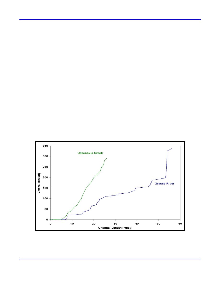
River profiles can be very useful in assessing jam locations since change in slope from steep to mild is highly correlated
with ice jamming during ice cover formation and breakup. For example, Figure 4 compares the uniformly steep profile of the
Cazenovia Creek upstream of Buffalo, New York, to the stepped pool-riffle profile of the Grasse River in northern New
York. Based on the river profile, the ice on Cazenovia Creek would be expected to break up and run en masse, forming a
single large jam near the mouth. The profile for Grasse River suggests a downstream-progressing sequence of breakups,
jams, and releases. Field evidence verifies these assertions.
Figure 4. Comparison of Cazenovia Creek and Grasse River bed profiles.
The locations of structures, particularly dams and bridges, and their current condition are equally important in the
identification of deposition and scour areas as these structures may retain or delay release of the ice cover during breakup.
Analysis of maps and river profiles can also provide information on upstream ice and sediment source areas.
4
ERDC/CRREL TN-05-1


 Previous Page
