680
660
640
620
600
580
560
540
520
1960
1965
1970
1975
1980
1985
1990
1995
2000
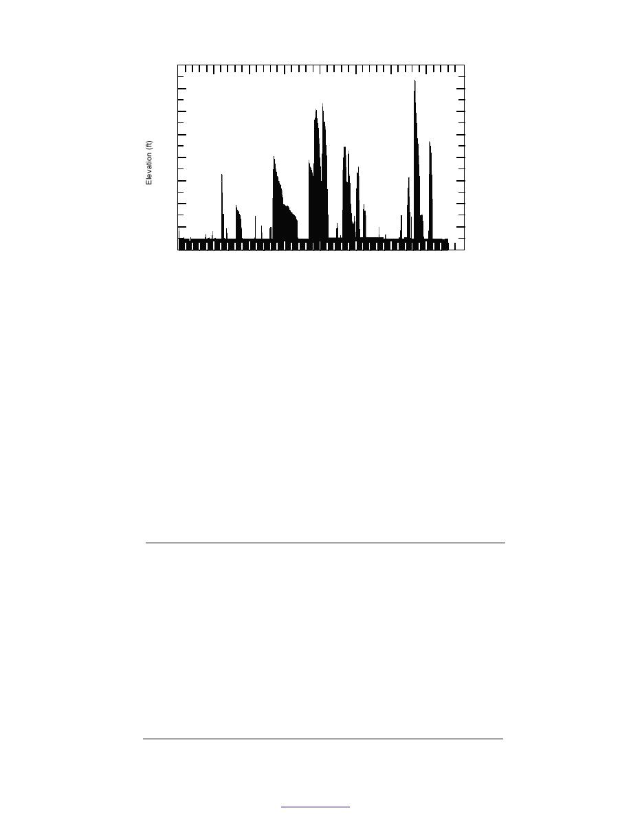
Figure 2. Water surface elevation of Painted Rock Reservoir, 19591997. Ele-
vation is in ft above MSL. Flood of record occurred in 1993. (Graphic provided
by Gregory Peacock.)
miles, with repeat coverage every 16 days. The
DATA
TM instrument records the earth's reflected radi-
Landsat TM remotely sensed data, Digital Line
ation in six spectral bands (Band 1, blue; Band 2,
Graph (DLG) data from the U.S. Geological Sur-
green; Band 3, red; Band 4, near-infrared; and
vey, reservoir elevation data from the time of the
Bands 5 and 7, mid-infrared) and its emitted
Landsat overpasses, area and capacity data from
(thermal) radiation in one band (Band 6). Each
previous surveys, and 1993 ground survey pro-
Landsat TM scene covers a ground area of about
100 100 miles, with a pixel size of approximately
files were used for this project.
one-fifth of an acre (28.5 m 28.5 m). Additional
background information on Landsat is available
Landsat Thematic Mapper data
The first Landsat satellite was launched in
on the World Wide Web (USGS 1998a).
1972; Landsats 4 and 5 are still operating. They
Nineteen Landsat TM scenes were used for
orbit the earth at an altitude of approximately 450
this project (Table 1). All are located at Path 37,
Table 1. Landsat scenes of Painted Rock Reservoir.
Acquisition
Sun
Sun
Weather
Acquisition
time
elevation
azimuth
over
Entity ID
date
(GMT)
(degrees)
(degrees)
reservoir
LT5037037009306610
7 Mar 93
17:26
40.00
134.00
Clear
LT4037037009309010
31 Mar 93
17:17
47.56
126.02
Clear
LT5037037009309810
8 Apr 93
17:26
51.60
125.79
Clear
LT5037037009311410
24 Apr 93
17:26
56.26
120.01
Clear
LT5037037009313010
10 May 93
17:26
59.64
113.56
Clear
LT5037037009314610
26 May 93
17:26
61.51
107.41
Clear
LT5037037009317810
27 June 93
17:26
61.43
101.81
Clear
LT5037037009321010
29 July 93
17:26
58.47
108.75
Clouds at E. end
LT5037037009324210
30 Aug 93
17:26
53.39
123.74
Clear (1 sm. cloud)
LT5037037009327410
1 Oct 93
17:26
45.62
138.84
Clear
LT5037037009330610
2 Nov 93
17:26
36.35
148.31
Clear
LT5037037009333810
4 Dec 93
17:25
28.87
150.69
Clear
LT5037037009504010
9 Feb 95
17:15
30.84
138.32
Haze
LT5037037009507210
13 Mar 95
17:14
40.58
130.31
Clear
LT5037037009510410
14 Apr 95
17:12
50.93
120.16
Wispy clouds
LT5037037009513610
16 May 95
17:11
57.50
107.56
Wispy clouds
LT5037037009516810
17 June 95
17:10
58.49
98.93
Clear
LT5037037009520010
19 July 95
17:08
55.97
101.40
Many puffy clouds
LT5037037009523210
20 Aug 95
17:07
51.64
113.35
Clouds SE
3
Back to contents


 Previous Page
