

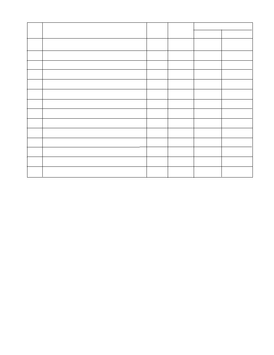
Areal coverage
Map
Map name
Revision
Scale
no.
(translated)
date
(1:_____)
Longitude*
7500′
13850′
East Siberian SeaNovosibirskiye Islands, Sannikova and
953
1991
500,000
7216′
15205′
Dmitriya Lapteva Straits
7429′
15050′
East Siberian SeaIndigirka River delta to Shalaupova
954
1991
700,000
6920′
17330′
Island
7230′
17200′
East Siberian and Chukchi SeasSchapovalov Island to
955
1991
700,000
6650′
W16520′
Cape Golovin
6738′
17015′
Pacific OceanNorthern part of Bering Strait
1085
1978
2,000,000
5845′
W16300′
6436′
W17415′
Bering Sea; Chukotskiy PeninsulaCape Yakun to
1088
1978
250,000
6318′
W17015′
Cape Mertensa with St. Lawrence Island
6435′00″
W17339′21″
Bering Sea; Chukotskiy PeninsulaProvideniya Harbor
1089
1979
50,000
6414′10″
W17303′51″
6610′
W17130′
Bering Sea, northern part; Bering Strait
1096
1979
250,000
6456′
W16730′
7642′
8642′
12330†
Kara SeaRingnes Island to Gavrilova Island
1993
200,000
7535′
9306′
7730′
9734′
12332†
Kara Sea; Taymyr PeninsulaKnipovicha Bay to
1993
200,000
7602′
10818′
Cape Poluostrovnoy
6956′
3408′
Barents SeaMurmansk Shore, Kildin Island to Voroni
13005
1993
100,000
6907′
3551′
Luki Islands
6932′
5842′
Barents Sea, Southeastern partCape Medynski Zavorot to
13028
1993
100,000
6856′
6101′
Cape Chayka with Dolgiy Island
7013′
6104′
Kara Sea; Yugor PeninsulaMestnyi Island to Svyaschenyi
13317
1993
100,000
6938′
6325′
Znak Schpindlera
7015′12″
8220′00″
River Yenisey; Channel GolovinApproaches to Nosok
15352
1993
25,000
7006′00″
8350′00″
Village
6957′40″
8324′45″
River YeniseyFairway to the south from Bolshoy Island
18389
1993
10,000
6952′40″
8335′24″
* All latitudes are east of the prime meridian through Greenwich, England, unless otherwise listed.
†
Map has both Russian and English labeling.
67

 Previous Page
