Damage criteria
ral and ship-induced hydraulic forces are free to
A major problem in setting damage criteria is
act on the low bluff on the waters edge during a
high-water period. This bluff is frequently con-
in defining levels of ship-induced effects that are
sidered to be the shoreline by many property
either undesirable or unacceptable. It cannot be
owners. If the water level were lower, the water
realistically required that ships cause no sediment
would not act directly against this "shore" but
motion, even if it were possible to accurately pre-
on the mildly sloping beach below. Persistent
dict the transient, ship-induced threshold of mo-
erosive forces might eventually erode back to the
tion in the large, irregularly shaped channels con-
bluff, but in the interim the rate of material loss
sidered. Small sediment dislocations should not
would be less since the mild sloping beach would
necessarily be considered damaging, particularly
dissipate the energy more efficiently.
since natural currents, waves, recreational boat-
In addition to the lack of predictability for ship
ing and other factors are often more significant.
waves discussed earlier, there is almost no in-
At the other extreme, ships may cause large
formation available to examine their ability to
water-level fluctuations and currents that would
cause sediment movement. Wuebben et al. (1984)
cause unacceptable levels of sediment transport,
assumed that ship waves were similar to wind-
shoreline erosion and structural damage, as well
driven gravity waves, so that coastal sediment
as affecting recreation and personal safety. Be-
transport theory could be applied. This assump-
tween these extremes the increase in significance
tion is reasonable in deep water, but the validity
of ship effects is gradual, so it is difficult to de-
of its extension to shallow nearshore zones is un-
fine a precise threshold where the effects become
certain. Wuebben then used information presented
unacceptable. Any criterion must consider site-
in the Shore Protection Manual (USACERC 1984)
specific conditions of shoreline geometry and com-
to propose a nearshore wave height of 0.5 ft as a
position, vessel speeds and water levels. Predic-
criterion for the onset of sediment motion. De-
tions of vessel effects are most often premised on
pending on the depth of nearshore water, lower
existing speed limits, but if these limits are not
wave heights could indeed cause transport, but
observed, these effects can be severely underes-
due to the oscillatory nature of water movement
timated. Since drawdown increases as the square
in waves, motion does not necessarily imply ero-
of ship velocity, ship effects can increase rapidly
sion. In addition, the criterion assumes a sand
for small increments above those speed limits. In
bed system, and no information was found to deal
contrast, properly developed and enforced speed
with the cohesive sediments that are widespread
limits could effectively eliminate ship-induced
in the Great Lakes system. Since cohesive sedi-
damages.
ments and materials larger than sand are more
The water level is another important variable
resistant to erosion, any error would be on the
in determining vessel effects, and it cannot be to-
conservative side, and predictions could be tem-
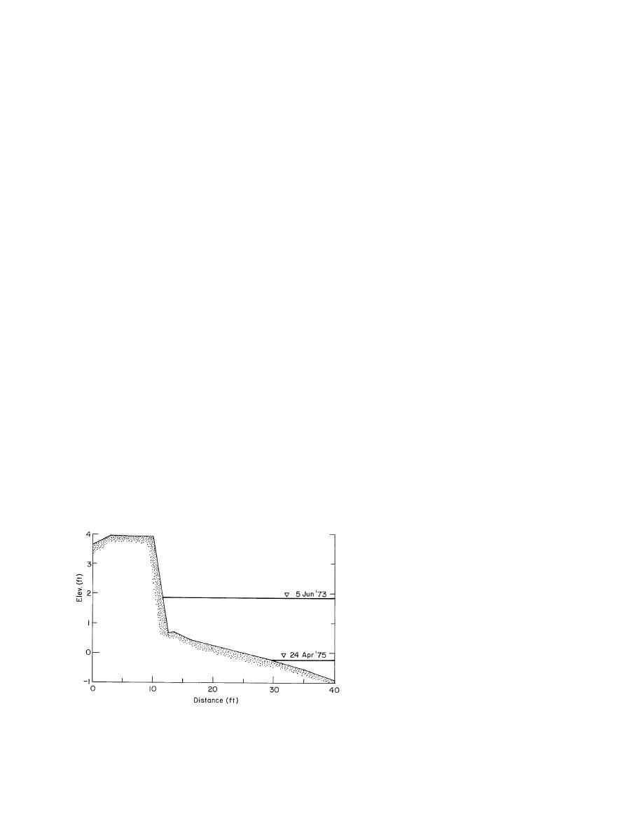
tally controlled. As shown in Figure 7 for a typi-
pered with engineering judgment. While this cri-
cal shore profile on the St. Marys River, both natu-
terion is somewhat arbitrary, it did provide
a useful tool for locating potential damage
sites. However, for winter navigation, ship-
generated waves are of negligible impor-
tance because they are nearly immediately
damped by ice.
Hochstein and Adams (1985b) adapted
a model that considers both drawdown and
the effects of propeller wash to the St. Marys
River. They noted that bottom disturbance
is a function of distance from the propeller
axis to the bottom and that disturbances are
greatest in channel bends and reaches where
crosswinds force vessels to crab their sail-
ing line. Using a combination of basic theory
and empiricism, their model produces two-
Figure 7. Relation of water level to a shore profile on the St. dimensional distributions of water veloci-
Marys River. (From Wuebben 1983a.)
ties. It was then assumed that sediment trans-
10


 Previous Page
