1994 Arctic Ocean Section
0
surface and increasing to 34‰ at depth. In general,
the thicker ice had greater salinities near the bottom.
50
Examination of the crystalline structure revealed
that 89% of the total ice sampled consisted of colum-
100
nar ice. Of the remainder, 9% consisted of granular
150
or frazil ice, and 2% contained platey ice, large platelet-
type ice that may have been associated with freezing
200
of under-ice melt ponds as suggested by Jeffries et al.
(1995). Much of the granular ice was associated with
250
previously deformed ice, identified by inclined colum-
300
nar crystals in adjacent sections typical of tilted blocks.
0 0
2
4
2
1
Temperature (C)
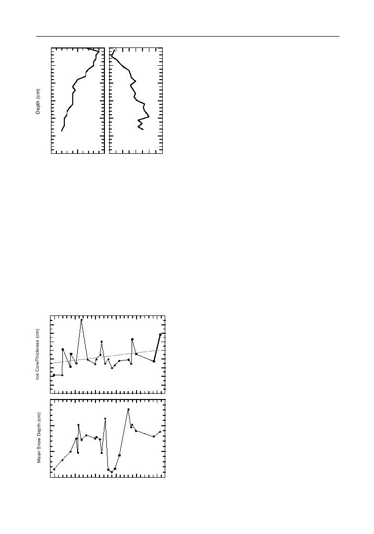
Surveys of snow depth were obtained at all ice sam-
Salinity (‰)
pling stations. South of 80 in the western Arctic, the ice appeared to be snow
Temperature and
salinity profiles for
covered, with very few bare ice spots visible. Close inspection of the snow
the same core from
cover characteristics revealed very large grains, close to 1 cm in diameter. We
the North Pole.
believe this indicates thermally deteriorated ice, rather than snow. Survey meas-
urements showed mean depths of 613 cm of the deteriorated ice. Between
80 and 82N metamorphosed corn snow was evident. In this region, mean
depths ranged from 10 to 15 cm. From 83 to 86N depths of the old corn
snow decreased to 68 cm. North of 86 and into the eastern Arctic, new snow
Ice core thickness
was present, generally covering the old coarse snow, and the combined depths
and mean snow
were 615 cm. At all sites north of 80, snow depths were variable, usually 0
depth versus lati-
5 cm on flat thin ice and up to 46 cm on the flanks of pressure ridges. North
tude during AOS-94.
of 85 it appeared that the melt season was complete, and the depth of the
The straight line is
the best-fit linear
regression. aged snow may represent the minimum for the 1994 ablation season.
Melt ponds in the Chukchi and southern Beau-
fort Seas were numerous, but farther north the ponds
400
began to freeze and eventually became snow covered.
Image analysis of aerial photographs obtained from
300
helicopter surveys allowed quantitative estimates of
200
the melt pond fraction. On 31 July at 76N the total
pond fraction was 12% and the lead fraction was
100
6%. On 13 August at 86N the open pond fraction
was 3%, yet 10% consisted of identifiable frozen
0
20
ponds with a 2- to 5-cm ice cover. The lead fraction
had increased to 11%. At 88N on 18 August no
open ponds were identified in the photographs, but
15
an areal fraction of 3% frozen ponds was evident.
The open water fraction remained at 11%. Measured
10
melt pond depths ranged from 20 to 60 cm. Six of
the 19 ponds sampled were saline and highly strati-
fied, with near zero salinity at the surface to 30‰ at
5
70
75
80
85
90
85
Latitude (N)
the bottom of the ponds. Saline ponds, though ap-
Pacific
Atlantic
82


 Previous Page
