mon basis for potential damage mechanisms dis-
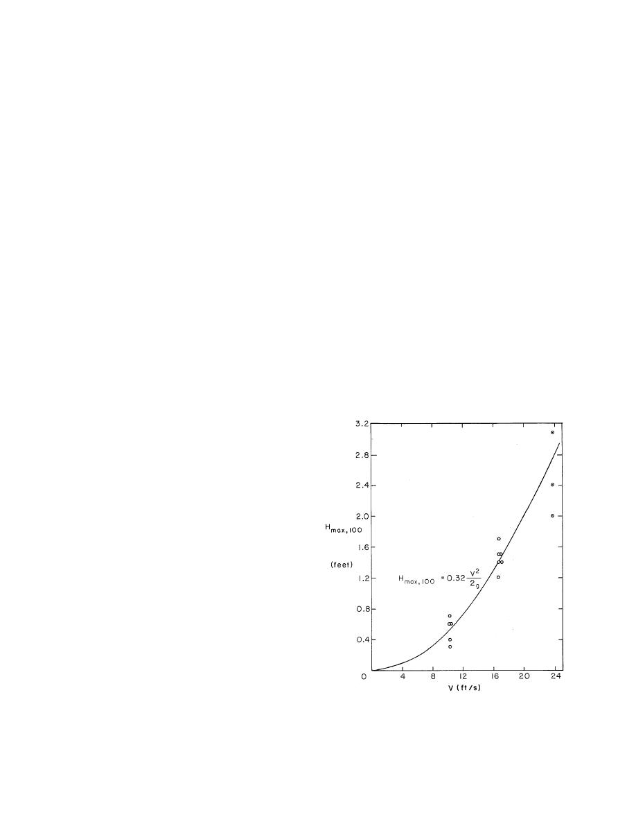
rily a function of vessel speed (Gates and Herbich
cussed in later sections dealing with specific im-
1977). Figure 2 was developed by Ashton (1974a)
pacts.
from data presented by Sorenson (1973) for waves
generated by boats with displacements from 3 to
343 tons. These data were derived from measure-
Physical effects of
ments in the Oakland Estuary (California) in a
commercial navigation in ice
Vessel passage through confined waterways
water depth of about 35 ft for various ship speeds.
may result in changes in the pattern and magni-
Although this figure ignores depth and draft ef-
tude of water motion due to ship-generated waves,
fects, there is remarkably little scatter. The figure
propeller wash, and drawdown and surge. A con-
serves to show the strong relation between the
fined waterway is defined as one in which the
maximum wave height 100 ft from the sailing line
shoreline or bottom is close enough to influence
Hmax,100 and ship velocity V. In fact, Ofuya (1970),
ship-generated water movements. These changes
in his study of ship waves on the Great Lakes
in the flow of water can, if large enough, cause
connecting channels, concluded that the essen-
the movement of particulate materials, leading
tial parameters influencing wave height were ship
to erosion of the shoreline and the channel bed,
speed and distance from the sailing line. He was
damage to shoreline structures, increases in tur-
unable to factor out the effects of vessel size or
bidity and other chemical and biological effects.
hull geometry due to the small variations caused
In addition to these mechanisms, which occur year-
by factors other than vessel speed. Ofuya also cited
round, additional effects during navigation in ice
the results of wave data collection at three sites
might occur due to direct movement of ice in con-
on the St. Clair River and one each on the Detroit
tact with vessels, by disruption of stable natural
and St. Lawrence Rivers. For gauges located in
ice covers, and through interaction of vessel-in-
525 ft of water, very few waves were measured
duced hydraulic effects with the ice cover. The
in excess of 0.6 ft, and then only when the speed
size and significance of these potential mecha-
limit was significantly exceeded. Further data on
nisms depend on a number of local conditions,
ship-generated, open-water waves on the Great
such as the bathymetry, water levels, surficial soil
Lakes connecting channels are presented in the
conditions, ice conditions, shore and shore struc-
report by USACE-SLSA (1972).
ture composition and geometry, and presence of
other natural agents such as water currents or
waves.
Ship waves
The generation of water waves during vessel
passage is the mode of action most often associ-
ated with ship-induced effects in the nearshore
zone. When a ship sails in ice-free open water, a
system of diverging and transverse waves develop.
Diverging waves are those that form the familiar
V-shaped wave pattern starting at the bow of a
ship, while transverse waves form a less notice-
able wave train that follows the vessel and is ori-
ented normal to the sailing line.
Due to the decay of the waves as they propa-
gate away from the ship and the interaction be-
tween these dissimilar wave sets, the generated
wave heights are a strong function of position.
The location of maximum wave heights, referred
to as cusps, occur where the crests of the two wave
types intersect so that they reinforce each other.
The wave heights at these cusp locations decrease
inversely proportionally to about the cube root
of the distance from the disturbance.
Figure 2. Maximum wave heights 100 ft from the sail-
The height of ship-generated waves is prima-
ing line for a variety of hull forms. (From Ashton 1974.)
3


 Previous Page
